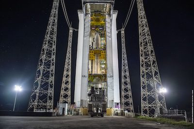
[caption id="attachment_464739" align="alignleft" width="400"] Hissage PAC en ZLV, le 26/08/2024. | PAC hoisting at ZLV. 08/26/2024.[/caption]
In preparation for liftoff on Sept. 4, 2024, the Vega–Sentinel-2C upper-composite has been hoisted into the launch tower at Europe’s Spaceport.
The Sentinel-2 mission is based on a constellation of two identical satellites, Sentinel-2A (launched in 2015) and Sentinel-2B (launched in 2017), flying in the same orbit but 180 degrees apart to optimize coverage and revisit time.
Each satellite carries a high-resolution multispectral imager to deliver optical images from the visible to the shortwave-infrared region of the electromagnetic spectrum. From an altitude of 786 kilometers, the satellites provide images in 13 spectral bands with resolutions of 10, 20 and 60 meters over a large swath width of 290 kilometers.
Data collected from Sentinel-2 are used for a wide range of applications, including precision farming, water-quality monitoring, natural-disaster management and methane-emission detection.
Once in orbit, Sentinel-2C will replace its predecessor, Sentinel-2A, while Sentinel-2D will later replace Sentinel-2B.
Image Credit: ESA-CNES-ARIANESPACE/Optique vidéo du CSG–T. Leduc
News
Sentinel-2C in the Vega Launch Tower