Top Stories
HySpex Imagery: True Color and Combined with Other Data Sources
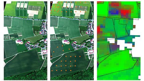
On the left we see a high-resolution HySpex image of the Puch test area in true colors, taken on May 12, 2025. In the center is the same image with locations of drone acquisition points (orange). And on the right, land cover derived from EnMAP satellite data. Pixel colors denote photosynthetically active (“live”) vegetation in green, non-photosynthetically active (“dry” or “dead”) vegetation in blue and open ground in red. Buildings are not relevant for this analysis and are marked white. Land cover is an important parameter of the land surface, especially in agricultural systems: it underpins modelling of soil parameters, monitoring soil erosion and identifying land degradation.
Image Credit: DLR (CC BY-NC-ND 3.0)